RAJASTHAN RIVERS
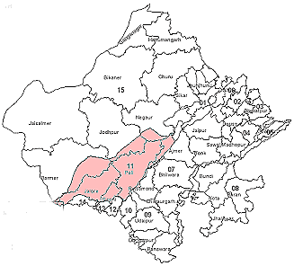
Luni River Basin is located in south-western Rajasthan, It is bounded by the arid western districts (The Outside Basins) in the west, by Banas Basin in the east, Shekhawati Basin in the north, and Sukli and West Banas Basins in the south.
The Basin extends over parts of Ajmer, Barmer, Jalore, Jodhpur, Nagaur, Pali, Rajsamand, Sirohi and Udaipur Districts.
Luni River Basin lies to the west of the Aravali hills and forms part of the mid-west alluvial plain. Orographically, the eastern part of the Basin is marked by hilly terrain belonging to the Aravali chain. West of the hills lies a narrow alluvial plain which gently slopes westwards. Luni River originates in Ajmer and flows to the Rann of Kutch in Gujarat State.
2. Drainage
River Luni originates in the western slopes of the Aravali range at an elevation of 550 m, near Ajmer. After flowing for about 495 km in a south-westerly direction in Rajasthan, the river disappears in the marshy land of Runn of Kutch.
The water of River Luni is sweet up to Balotra and becomes more and more saline further downstream. The main tributaries of Luni on the left are Sukri, Mithri, Bandi, Khari, Jawai, Guhiya and Sagi, whereas only Jojari river joins it on the right side
3. Rainfall
The mean annual rainfall over the Luni Basin was computed as 320 mm, of which about 97% falls during the four Monsoon months (June-September).
4. Existing Surface water Projects
There are 2 Major (Sardar Samand and Jawai dam), 9 Medium and 344 Minor irrigation projects in the Luni River Basin, as well as some small irrigation systems (covering less than 20 ha) constructed and operated by Panchayat Samities (PS).
5. Ongoing Surface Water Projects
4 irrigation projects, with a total live storage capacity of 11 Mm3, are under construction in the Luni Basin. An additional area of 2514 ha will be irrigated on completion of these projects.
4 irrigation projects, with a total live storage capacity of 11 Mm3, are under construction in the Luni Basin. An additional area of 2514 ha will be irrigated on completion of these projects.
6. Proposed Surface Water Projects
25 irrigation projects, with a total live storage capacity of 57 Mm3, have been proposed by the ID in this Basin. An additional area of 8399 ha will be irrigated on completion of these projects.
25 irrigation projects, with a total live storage capacity of 57 Mm3, have been proposed by the ID in this Basin. An additional area of 8399 ha will be irrigated on completion of these projects.
Tributaries of Luni on the Left side
1. Sukari==>>River Sukri is formed by the confluence of several small nallahs - Ghanerav Nadi, Muthana ka Bala, Magai Nadi etc., originating from the Aravalis in Pali and Udaipur Districts. It flows for about 110 km in a south-east to north-west direction, and feeds Bankli Dam on the way. It joins River Luni near the village Samdari in Barmer District. This Sub-Basin covers parts of Jalore, Pali and Barmer Districts.
3. Bandhi (Hemawas)==>>Khari and Mithari rivers join near Bombadra pickup weir and form the Bandi River. It joins the Luni near the village Lakhar, in Pali District, after flowing for about 45 km. The catchment is situated in Pali District.
4. Khari (Hemawas)==>>River Khari is formed by the confluence of small streams namely Somesar and Khari Kherwa. River Somesar (originally known as Sumer Nadi) originates in the western slopes of the Aravali range near the village Somesar in Pali District. The stream Umrawas Ka Nalla, originating in the western slopes of the Aravali, near village Kanklawas, joins Sumer Nadi. Kotki Nadi, originating from Dewair Reserved Forest Bhakar also joins Sumer Nadi after flowing for about 30 km. After joining of all these small streams, the river is called Khari. It joins Bandi river downstream of Hemawas reservoir after flowing for about 25 km.
5. Jawai==>>River Jawai, and its main tributary Sukari, originate in the western slopes of the Aravalis, in Udaipur District. The river flows generally in a north-west direction for about 96 km, before joining River Khari near the village Sayala in Jalore District.
6. Guhiya==>>River Guhiya originates in the hillocks near the villages Khariyaniv and Tharasani in Pali District. It joins river Bandi near village Phekariya in Pali District. The catchment is situated in Pali district.
Tributaries: Raipur Luni, Radia Nadi, Guria Nadi, Lilri Nadi, Sukari and Phunpharia.
7. Sagi ==>>River Sagi originates in the south-western slopes of Jaswantpura hills in Jalore District. It flows initially for about 72 km northwest and then southwest before joining the Luni near Gandhav village in Barmer District. Kari Nadi is the only tributary of River Sagi. The catchment extends over parts of Jalore and Barmer Districts.
8. Sukri (Sayala to Luni)==>>River Jawai, after its confluence with the Khari river is called Sukri. It flows in a southwest direction for about 80 km before joining the Luni river near Golia village. The catchment extends over parts of Jalore and Barmer Districts.
Tributaries: Krishnawati and Kameri.
9. Bandi==>>River Bandi is formed by the confluence of Kapal Ganga Nadi, originating in the hills near village Seankra, and Jaswantpura Nallah, originating in the hills near Nivaj village in Sirohi District. It flows generally in a northwest direction for about 65 km and finally vanishes in the west.
10. Khari==>>River Khari originates in the south-western slopes of the Aravali hills, near Shergaon village in Sirohi District. It flows north-west for about 64 km before joining the Sukri river near Sayala village in Jalore District. The catchment extends Sirohi and Jalore Districts.
Tributaries: Krishnawati and Kameri.
1. Jojari==>>River Jojari originates in the hillocks near village Pondlu in Nagaur District, it flows for about 83 km from north-east to south-west before joining Luni river near the village Khejadli Khurd in Jodhpur District. The catchment extends over Jodhpur and Nagaur Districts.
No comments:
Post a Comment